The land tracts on which the "Le Poste de Pointe Coupée" and "L'Église St-François d’Assise" (the 1760 church) were located can be found on LA 981 in New Roads, Louisiana, LA 981 is also called Ferry Road - a reference to the St. Francisville ferry landing which was located on this road before the recent construction of the St. Francisville bridge. This road runs parallel to the Mississippi River.
The original church at Pointe Coupée was dedicated in 1738. The location of that site is unknown. The church location outlined below is the church which was built in 1760 and stood until approximately 1892/93. (The picture below is the 1760 church.) Attached to the 1760 church was the burial ground for a large number of our Avoyelles ancestors. Sadly, many of the graves originally located in this cemetery were swallowed by the Mississippi River. A small number of graves were transferred to St. Mary's Church in New Roads but there were no graves transferred for any individual who died prior to 1818.
Click here to see an explanation written by Pointe Coupée historian, Brian Costello, regarding the burial of our early ancestors at St. Francis and the loss of these precious gravesites due to the encroachment of the Mississippi River.

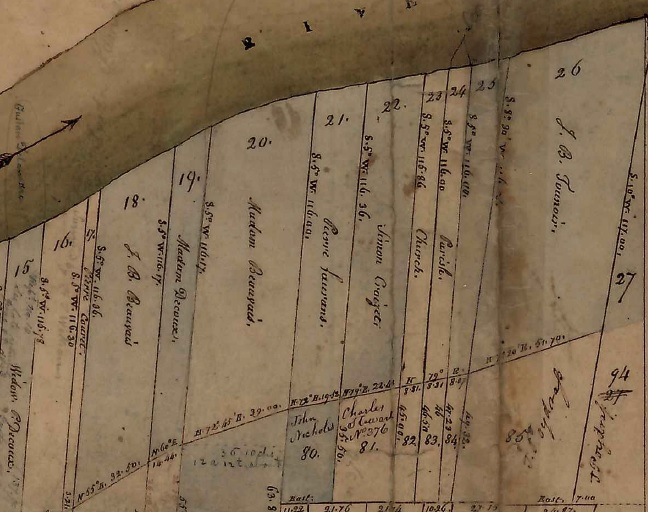
Land tract #23 was the church tract; #24 was the poste tract. These two tracts can be seen in the following old map from the 1800s. The Poste tract is listed as 'Parish':

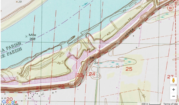
When traveling east on LA 981, the western edge of tract #23 is located approximately at the location of the first 'arrow' road sign indicating a sharp curve. The eastern edge of tract #24 can be found approximately .5 of a mile east of this location.
According to Pointe Coupée historian, Brian Costello, "the diagonal cut going from present river bank to levee is crevasse scar from levee breaks of 1867 and 1882. The new levee was made to curve around the crevasse lake and the church and cemetery by 1890, causing the demolition of the church, and the site soon caved into the river".

You will note on the following map that both tracts now extend far into the Mississippi River. This is an indication of the extensive erosion of the original river bank.

From "The Angel Ranch Project Area" ("Exhibit FF: Angel Ranch Site Partial Phase I Cultural Resources Assessment Report"; April 2015; Coastal Environments, Inc.):
"Since at least 1834 the movement of the Mississippi River channel has impacted cultural remains within and adjacent to the project area. From the center of the project area, more than 550 m (1,804 ft) of land has eroded into the Mississippi River from the west bank of the river. An average rate of 3.68 m (12.07 ft) of land per year was lost to erosion over 150 year period prior to 1980 (Hahn et. al. 2003:8-9). The St. Francis of Assisi Church was founded just north of the current project area, along the west bank of the Mississippi River in the mid-eighteenth century. However, the church and the community surrounding it were destroyed by the movement of the river, and their original location is now 350 m (1,148.35 ft) to the north of the current bankline, placing it in the middle of the present Mississippi river course. Further east, there has been comparatively little movement in the Mississippi River channel since the mid-1800s, and the potential for older cultural remains is highter in these areas."

Note: Governor Bienville established a military post c1717 about one mile above the present town of Waterloo on the Mississippi River in Pointe Coupée Parish. In 1840, ramparts could still be seen at this location. About 1722, the fort was moved four miles up the river to the location described above.

In 1980, two LSU architecture students were collecting field data on a vacant house along the Mississippi River in Pointe Coupée Parish on a tract of land known as "Brunswick Plantation". The house, with a federal/victorian facade, had been the birthplace of "Lindy" Boggs in 1916. As you may remember, Marie Corinne Morrison Claiborne "Lindy" Boggs had become a U.S. Representative after she, successfully, ran for the seat vacated by her husband, Hale Boggs, in 1973 after his disappearance over Alaska in a presumed airplane crash. (In 1997, she became the U.S. ambassador to the Holy See.)
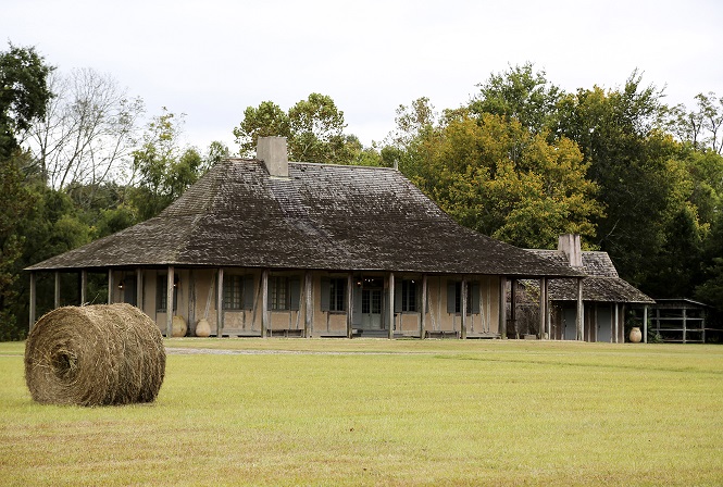
As the 1980 LSU field data project progressed, it became obvious that a much older building was behind the odd facade. Significant architectural elements dated the house to the early part of the 18th century. In the years that followed, the house was purchased and moved to another location in southern Louisiana. After a series of unexpected twists and turns, the house was purchased in 1996 by four individuals including Dr. Jack and Mrs. Pat Holden. The house now resides on their property in Jarreau, Louisiana and is not open to the public. Here is a photo of the house as it looks today:

An investigation into the origins of the house (including an Abstract of Title developed by Brian Costello in 2003 for the owners) led to the discovery and confirmation that the land on which the house resided had originally belonged to Nicolas de la Cour and the house, based on the architectural elements, was likely built during his lifetime.
It is a large two-room house and, according to Mrs. Pat Holden, the house was, possibly, double in size from the current structure. As she pointed out during our 7 October 2016 visit to the house, connective pieces of the house were numbered with roman numerals and the first fifteen were missing from the structure when it was discovered in 1980. This has led them to theorize that the house/structure might have been divided in two at some point. As others have pointed out, it is possible that this was the home of the Pointe Coupée Commandant in the early/mid 1700s.
The succession of ownership on the house and land are as follows:
1746: Jean Baptiste Bara dit LeBlond sells to Nicholas LaCour - a plantation fronting 16 arpents on the Mississippi River ..."with fences, barns and other buildings";
1761: The wife of Nicolas de La Cour died in March; Nicolas died in December of the same year;
1766: The Census listed Jean Baptiste LaCour with eight arpents' frontage. The tract of land adjacent on the west side to that of Jean Baptiste's land also had eight arpents' frontage and was owned by his brother, Nicolas 'Colin' LaCour. It is believed that these two tracts were likely inherited by the two youngest sons of Nicolas de la Cour and Perrine Bret in 1761. As Brian Costello points out in his 2003 Abstract of Title, it is possible that the plantation home was divided in two and the other half given to Nicolas "Colin" Lacour at the time of their father's death although there is no supporting documentation found to date to prove this.
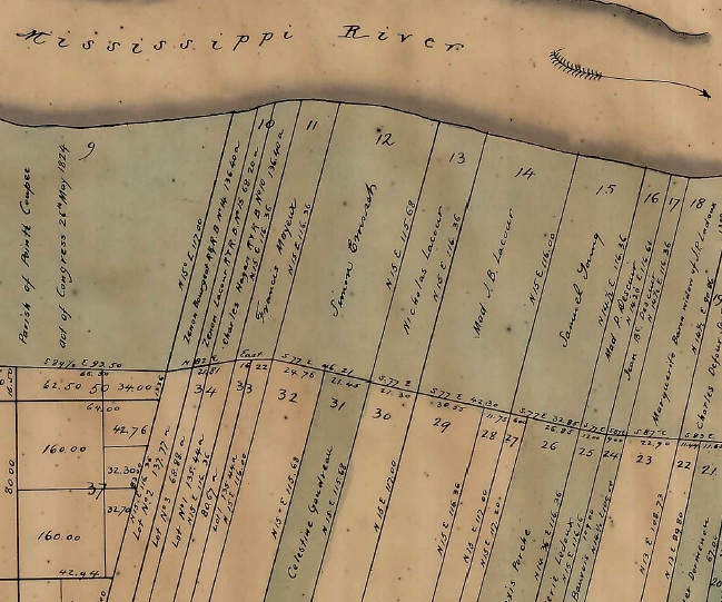
1790: Jean Baptiste LaCour died. An inventory of his succession showed that he owned 12 arpents' frontage on the Mississippi "including a house 55' wide, with galleries front and rear...". The drawings of the house including dimensions are found in this document in the Library of Congress. The current structure is not 55 feet in length or width but it is unknown if the 1790 measurements were correct. The fact that he owned 12 arpents' frontage at the time of his death rather than the original eight is also significant. I suspect that Jean Baptiste purchased some land from his brother, Nicolas Colin, who had the tract next to him. This will make more sense as I show you the 1829 map of the tracts.
1814: The Widow Jean Baptiste LaCour transferred the property to her son-in-law, Vincent Ternant, père.
1819: Constance LaCour, widow of Vincent Ternant, père, sold the property to Adélaïde Gosserand, widow of Jaccques Vignes.
1849: The property of was to Charles DeCoux as part of the succession sale of the Widow Jacques Vignes.
1853: Charles DeCoux sold the property to Garland Pendleton Ware.
1856: The land on which Brunswick Plantation was located was purchased on 7 August 1856 by Jacob Haight Morrison, the great-grandfather of "Lindy" Boggs, from Garland Pendleton Ware. It is unclear if this was the only purchase by Morrison from Ware; Brian Costello's Title Abstract mentions a 1866 sale of property. The three pieces of property listed in the 1856 document contain a total of 11 arpents' frontage.
There were several subsequent sales of the property to various Morrison family members (including Edward S. Morrison, the father of "Lindy" Boggs). After the death of Edward Morrison in 1923, the property passed into other hands until 1963 at which time the property, including the house, was purchased by the Thibaut family. This is the family who owned the house when it was 'discovered' in 1980.
Here's where the Lacour house was found and where was the original land of Nicolas de la Cour?

The land tracts on which Nicolas de la Cour (born 1701) lived can be found on LA 420 in New Roads, Louisiana. LA 420 is also called Pointe Coupée Road. This road runs parallel to the Mississippi River. (Note: It is possible that he had other land holdings also.) The tracts in question are #13 (Nicolas Colin Lacour) and #14 (Jean Baptiste Lacour) in Township 4S, Range 9E of Pointe Coupée Parish. Below is a 1829 land map of this township/range which clearly shows the land was still owned by the families of these two deceased men (Nicolas Colin Lacour had died in 1797).

If you'd like to drive past these two tracts of land, you can turn north on to LA 420 from LA 1 (there is an abandoned one-story school at this corner). The western edge of the Nicolas Colin Lacour tract (#13) is approximately 1.2 miles from the intersection of LA 420/LA 1. The eastern edge of the Nicolas Colin Lacour land (#13) (which is also the western edge of the Jean Baptiste Lacour land on #14) is located approximately .3 miles east down the road (in front of the cemetery of the Sixth Ward Baptist Church). The eastern edge of the Jean Baptiste Lacour land (#14) is approximately an additional .5 miles further down the road as you travel east.